- Home
- Accomodation
Accomodation in France
THEY TRUST US


- Activities
- Tourism
Tourism in France
 Tourism Lyon
 Tourism Paris
 Tourism Marseille
+
Tourism Marseille
+
Cultural places French Museum
 French monument
Vacation Seaside resort
 Winter sports resort
 Spa
Spa
- Tours
- Events
- Guides
- Location de voiture
Louer votre voiture de tourisme


- Blog


 Home
Home- > Tours
- > Languedoc-Roussillon
- > Lozère
- > Sainte-enimie
- > Hiking around sainte-enimie
Hiking around sainte-enimie
| Topic | Walks |
| Departure | SAINTE-ENIMIE (48) |
| Details | This tourist guide provides 4 walking routes from 2 to 15 km Sainte-Enimie to discover and splendor of its surroundings (Gorges du Tarn, Hauterives, Domain of Boissets ...). |
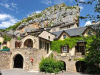
Hermitage of Sainte Enimie

From the car park situated on the Tarn, take the lane "The Tender" lying between the Hotel de Paris and the snack bar opposite the bridge.
You reach the road from Mende, cross it and take the street that goes up to 20m and then left the trail that runs behind the houses Saint Vincent Hermitage direction, the departure is paved with irregular stairs.
Departure from our villa, right down the road that joins the county towards Mende and take the path with climbing stairs between 2 large houses located before the stop sign, there is a signpost.
Continue the path to cross to the hermitage where you have a wonderful view over the village, the oldest pilgrimage route in the region. It was created in honor of Saint Enimie the tenth century by a Prior of the Abbey. The hermitage is closed due to vandalism.
Continue along the path that will take you to the Cross Oratory raised in Saint John, he gives you another perspective on the medieval town and the gorges of the Tarn.
Take the path to the left (when you turn your back on the cross) to descend on St. Enimie you get on Route de Mende, left following the main road back to the village.
In the evening you can admire the lights of the bridge and the cliffs of the hermitage.
Practical informations
- REF Map: IGN 2640 OT, hiking map Gorges du Tarn / La Jonte / Causse Mejean
- Distance: 2km
- Duration: 1 hour to 1:30
- Level: intermediate, elevation 200m, narrow path
Accommodation nearby
Sainte Enimie - Prunets - Chaldas - Castelbouc - Sainte Enimie

From the car park at the edge of the Tarn, cross the bridge and after 250m take the left lane that leads to the subdivision, make a stop at "Lookout Jokers' for the overview of Sainte Enimie then follow the direction Prunet GR60 The climb is tough until a flat rock called THE POSADOU where you have a wonderful view over the village and the gorges of the Tarn
Continue until Prunet: you're on the Causse Mejean
In front, you see the Causse de Sauveterre and isolated farms
Continue straight on to the hamlet of Chamblon then let the GR 60 from the right and turn left towards Chalder (Trail Tour du Mejean)
Panorama from the top of the rock outcrop dominated by the "CONGRO"
Let the trail of the Tour du Mejean right and turn left to begin the descent on Castelbouc, overlooking the castle ruins. (Trail marked yellow / green)
Before following the path of linear Tarn on its left bank, will discover the beautiful village of Castelbouc with its stone houses nestled at the foot of the castle! "
Observe the architecture of the chapel caussenarde semi-troglodyte dedicated to St. John the Baptist fourteenth century at the entrance of the hamlet, the curious monument to the dead, the doors and windows of the church (country house converted into a church 1844, is dedicated to Saint precursor, with the purchase of another house in 1873 it is expanded).
The return on St. Enimie the trail edge of the Tarn is very shady and pleasant as with swimming
Prades and you will see the castle of the twelfth century, then 1.5 miles before you follow the Holy Enimie Leisure
You will arrive at St. Enimie by the path of the subdivision then the bridge.
Practical informations
- REF Map: IGN 2640 OT hiking map Gorges du Tarn / La Jonte / Causse Mejean
- Distance: 15.5 km
- Duration: 6:30
- Level: medium, 555 m elevation, plan the day, picnic and water, hat and good shoes, ATTENTION: on the mesa wind + sun = sunburn
Accommodation nearby
Hiking around Sainte Enimie

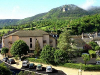
At the heart of the Gorges du Tarn, you can discover the heritage of this beautiful medieval city. Many views of the gorge and the Cevennes. Sainte Enimie is part of the "Most Beautiful Villages of France".
Parking, take the road straight down to the village. Have a hairpin turn and continue up the street on your left which becomes a path.
Take it and continue your ascent to the next crossroads. Take the path in front of you and continue to the next crossing.
Take the left path and continue up the road.
Turn left and continue up a path on your left.
Take it and proceed to next crossroads. Turn left at the next junction take the path down to your right. Keep up the forest track.
Turn right then immediately left. At the next junction go right and then left and get on the road to GR60.
Take the road in front of you and continue until you reach the starting point.
Practical information
- Departure: parking college Pierre Delmas top of the village
- Distance: 6.7 km
- Duration: 3 hours
- Elevation: 425 meters (500 - 925 m)
- Circuit completely unmarked
Outstanding sites
- Sainte Enimie medieval village
- Hermitage Holy Enimie
- The terraces
- Domaine des Boissets
- Jackstay Aubrac (GR60)
Accommodation nearby
Trail of Saint-Chely du Tarn

It's a hike for lovers of old stones, to discover the architecture of villages of the Tarn Gorges and Causses, castles, terraced fields ... Walk to the multiple views of the circus ST Chely du Tarn and the Cirque de Pougnadoires, shaped by the Tarn over millions of years.
Take the direction of Millau and the D907 bis 5km park in Saint Chely du Tarn.
Take the small asphalt road that leads to the rear of the village and joins a road.
Climb the path on your left and after the yaw drive straight and follow the direction Caussignac. The climb is gradual to pass the Causse Mejean Coperlac sweats.
To pass coperlac cross the road (D986) towards du Mas Saint Chely. Turn right at the sign "jackstay Lozere", remember to close the gate of the sheepfold. Follow jackstay which passes through the upper village of Caussignac.
200m after the village turn right and follow the path joins the road D986. Cross it and walk across the footpath to the village of Anilhac.
On entering the village take the street on the right and follow it to the iron cross.
Turn right and walk to the edge of the mesa.
The trail plunges into the gorges of the Tarn, down the road link along the castle ruins Hauterives to trail the Tarn valley.
Turn left to visit the village of Hauterives and then retrace your steps and follow the path of the Tarn gorges along more or less near the river to return to the intersection of sections 1 and 2.
Same route to reach a point of departure and visit the village of St Chely du Tarn.
Practical Information
- Departure: the village square of St Chely du Tarn
- Distance: 15km
- Duration: rated at 6 o'clock
- Elevation: 441 meters (469 to 910 m)
- The loop circuit is completely marked, map explorer 48 South, IGN 2640 OT
Outstanding sites
- Saint Chely du Tarn
- The Gorges du Tarn
- Plain and Caussignac Anilhac
- Castle Hauterives
- Village Hauterives
- Chateau La Caze
Accommodation nearby
Latest news on : Hiking around Sainte-Enimie
Tourism near
 Visit the city of Sainte-enimie
 - 3 Monuments
Tours
 Tour to explore Aubrac
 Gorges du Tarn, causse Méjean, gorges de la Jonte
 Ispagnac
Events

Partners